SEDucate: sedimentary log exercises for an active learning environment
DOI:
https://doi.org/10.57035/journals/sdk.2023.e11.1014Keywords:
sedimentary logs, active learning, education, modern depositional environmentsAbstract
Active learning in higher education has been shown to improve students’ learning experience by focusing on a student-centered environment. However, the development of realistic activities that simulate the complexity of real world examples while being appropriate for novice learners is challenging. Here we present SEDucate, a GIS plugin to designed to build realistic active-learning exercises for sedimentology courses. SEDucate creates unique sedimentary logs for a tailored assessment based on modern sedimentary environments. The automated creation of simple sedimentary logs covering a variety of depositional environments can be implemented in a wide range of exercises and assessments for individual or group-based work. This novel GIS plugin facilitates teaching the characterization of sedimentary logs, the interpretation of paleogeography and the lateral variation observed in modern sedimentary environments.
Downloads
Lay summary
Here the authors present the SEDucate plugin for creating sedimentary log and paleogeographic reconstruction exercises based on simplified sedimentary logs of modern depositional environments. The teaching resourcesimplemented through an active learning approach are designed to complement existing sedimentology course curricula and teach students the importance of lateral variability in paleogeographic interpretations.
1. Introduction
For students to get the best possible learning experience, it is generally agreed that there needs to be a ‘constructive alignment’ between the taught material (the ‘learning outcomes’), how the material is taught and how it is assessed (e.g., Biggs, 1996). In particular, if the teaching material is of a practical nature, such as interpreting sedimentary logs, then both the teaching method and assessment should be adapted to that. Thus, instead of teaching using traditional lectures, a teacher-centered approach, it is better to use active learning techniques in the classroom, i.e., a student-centered approach. Similarly, the assessment should be closely related to the material used in class.
Many studies on active learning, including active learning in STEM disciplines at the university level, have been conducted. These studies strongly suggest that active learning improves students’ acquisition of concepts (e.g., Freeman et al., 2014, Deslauriers et al., 2019). Therefore, in the context of constructive alignment, active learning has been promoted for many years at many universities, and within geoscience curricula (e.g., Manduca et al., 2017). However, recent studies also suggest that teaching-centered techniques (e.g., lectures) remain the most common method in many STEM disciplines (Budd et al., 2013; Teasdale et al., 2017; Stains et al., 2018).
There are numerous of reasons that that can explain why active learning methods are not used, including the unfamiliarity with active learning, the resistance of students to active learning (Finelli et al., 2018), institutional barriers (Henderson-Hurley and Hurley, 2013), and the lack of training and teaching material (Lukes and McConnell, 2014; Deslauriers et al., 2019; Laursen and Rasmussen, 2019). It is quite understandable that in many cases there is a lack of such teaching material as it is quite time consuming to modify existing exercise sets or replace these completely. While for each STEM discipline the challenges are different, as the type of work and exercises involved are different (Reinholz et al., 2019), there is a clear need for a practical way to develop a large number of relevant problems that can be used in both teaching and assessment.
Several institutions and websites are dedicated to geoscience education. These include the Science Education Resource Center (SERC; serc.carleton.edu), the Center for Integrated Earth Science Education (iEarth, iearth.no), and Seds Online (sedsonline.com) to name a few. Within these valuable resources, several sedimentology specific teaching materials are available. These marterials are focused on teaching students how to interpret sedimentary deposits, sedimentary processes, and depositional environments. However, the complexity of real-world field examples often makes it difficult to introduce fundamental principles for novice geology students. In sedimentology, few teaching resources of sedimentary log exercises , suitable for an entry-level course curriculum, exist (Fritz and Moore, 1988; Raymond, 1995 p. 345; Nichols, 2009; Bristow, 2020). As such, there is a need for the development of interpretable sedimentary log exercises that may also show the lateral variability observed in modern sedimentary systems. Furthermore, it is important to supplement existing resources with a wide range of active-learning material since studies on teaching methods show that this addition positively improves student performances (Freeman et al., 2014, Deslauriers et al., 2019).
In this paper, we present a method and framework to create student-centered sedimentary log exercises for introductory sedimentology courses. We describe the method and show how sedimentary logs are created for many different types of depositional environments and how to use this material in various classroom settings and assessments.
2. Material and methods
Teaching and assessing the fundamentals of sedimentology require theoretical and practical experience creating sedimentary logs, characterizing sedimentary successions into facies and facies associations, and interpreting the paleogeography of past environments. Here we introduce a tool, called SEDucate, for creating sedimentary logs and paleogeography exercises based on modern depositional environments. Students may use this tool to make observations and interpret paleogeography.
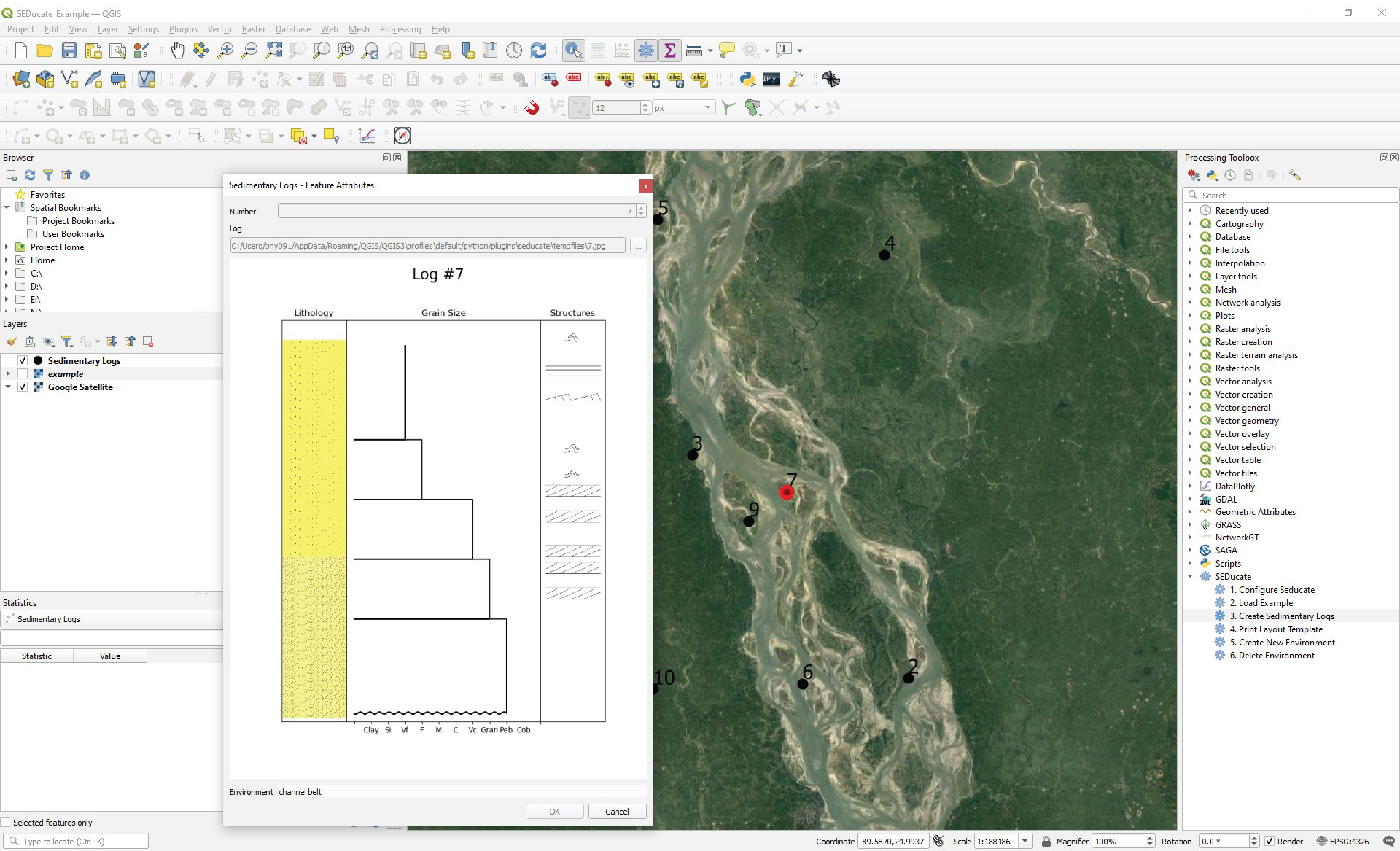
SEDucate is an open-source QGIS plugin used to construct sedimentary logs based on examples of modern depositional environments (Figure 1). The repository, the installation, and an initial set of resources accompanying user guide demonstrating the potential of the approach as an active-learning resource in sedimentology courses are available in the data availability section.
Figure 1. SEDucate Plugin - Example of the interactive QGIS interface and the SEDucate toolbox for creating sedimentary log exercises.
2.1. Sedimentary log profile
The nature of interpreting depositional environments, based on characterizing sedimentary layers into units of facies and facies association provides an opportunity to create tailored sedimentary log exercises. This is achieved by automatically creating a sedimentary log based on the knowledge that facies, facies associations or depositional environments that occur next to one another based on Walther’s law (Walther, 1894). By varying the vertical succession of facies, facies associations or depositional environments, a unique sedimentary log is created that varies vertically.
The creation of each facies, facies associations or depositional environments is based on predefined profiles produced as vector graphs within the Python scripting language (Figure 2). The profile is algorithm defined by specifying a starting grain size, a maximum grain size, a minimum grain size and its thickness ratio. The thickness ratio represents the relative thickness between the different environments in the creation of a vertical sedimentary log profile, for example, a channel belt followed by a floodplain environment (Figure 2). Optionally, a trend to the grain size profile may be selected as either coarsening upwards or fining upwards. Lastly, the contact at the base of each profile is defined as either sharp or erosional. Sedimentary structures corresponding to the depositional environment are subsequently added to each log section by relating the environment and grain size to the different types of structures. The algorithm will automatically create an idealised sedimentary log that honors the constraints dictated by the profile while varying the observed sedimentary structures.
In the initial version of SEDucate, sedimentary log profiles are available for 10 different depositional environments and sub-environments including: alluvial fan, channel belt, floodplain, eolian, lacustrine, shallow marine, turbidite, deep marine, delta channel and delta mouth bar settings (Table 1). The SEDucate interface also allows the creation of additional sedimentary log profiles that may be used to increase the number of environments or profile detail by defining the parameters mentioned above. Further information on the creation of new sedimentary environments is available in the User Guide on our GitHub page that is provided in the data availability section.
Figure 2. Sedimentary Log Profiles – Example sedimentary log profiles for shallow marine, alluvial fan and fluvial settings. Note the fluvial profile shows a combined channel belt and floodplain signature.
2.2. Sedimentary log creation
The creation of a sedimentary log based on a modern depositional environment is achieved by linking a map location to a sedimentary log profile. This requires a rasterized map of a modern depositional environment (or conceptualized paleogeography) with a code for each pixel (Figure 3A) that corresponds to the sedimentary profiles listed in Table 1. The algorithm samples the raster at each sedimentary log location to create a sedimentary log profile as previously described in section 2.1. Furthermore, digital elevation models may supplement the depositional environment map to include paleocurrent measures on the created sedimentary log that may be relevant in, for example, fluvial environments.
Currently, SEDucate requires a rasterized map to be manually defined prior to the creation of sedimentary logs. A few examples are provided within the SEDucate plugin. However, this also provides an opportunity to teach students fundamental concepts in GIS within a context of sedimentology by allowing them to create a depositional environment map for another student to interpret (see section 3.1). Furthermore, with the increasing accuracy and level of detail in global scale classifications including the Dynamic World (Brown et al., 2022) and the Global Channel Belt (GCB) map (Nyberg et al., 2022), it is hoped that the SEDucate will soon provide a range of different sedimentary environments for students to explore globally.
The locations of the sedimentary logs can be chosen manually or randomly within the extent of the depositional environment map (Figure 3). In the field, it is a common practice to describe multiple sedimentary logs from an outcrop or core to interpret the vertical and lateral variability and to best constrain the likely paleogeography. In a similar manner, the creation of the simplified sedimentary logs by the SEDucate plugin to describe a modern depositional environment may be used to illustrate the lateral variability that exists in the modern depositional environment.
Figure 3. (A) A simplified sedimentary environment map showing the distribution of floodplains and channel belts from the Brahmaputra, Bangladesh in Figure 1. Random locations for the sedimentary logs are numbered 1 to 10. (B) An uninterpreted map that students may use to interpret the paleogeography based on the sedimentary logs created at each location. The number of sedimentary logs provided to the students can be chosen and added sequentially to improve previous interpretations. See main text for more detail.
The example provided in Figure 3 shows the Brahmaputra River which is characterized by braided channels with an upward fining channel belt characteristic from gravel to fine sand over an 80 m scale (Coleman, 1969; Goodbred and Kuehl, 2000). Sedimentary structures defining the channel belt successions include trough cross-stratification, low-angle parallel lamination, plane parallel lamination, current ripple laminae and occasional soft sediment deformation caused by dewatering (Bristow, 1993). The SEDucate plugin can replicate the grain size trends and sedimentary structures found in the field by creating a custom sedimentary log profile (Figure 1) that modifies an existing log (e.g., Figure 2) or by creating a new one from scratch. While the figures produced by the SEDucate plugin do not contain an associated scale (see section 2.4), the scalable vector graphs may be adjusted accordingly to introduce scale variations between the sedimentary logs.
2.3. Lateral variation
Optionally, a probability matrix may be used to create variation in the vertical succession of a sedimentary log. This is achieved by sampling the lateral variability that surrounds a given sedimentary log locality by a user-specified search radius. Based on the number and category of pixels defined within each search radius, a probability matrix is created that informs the algorithm of the next sedimentary log profile to select in a vertical succession (Figure 4). The number of sedimentary log profiles to select is also user-specified. This allows for subtle variations in the vertical trend of a sedimentary log to show the shorter timescale variability that may arise laterally across a sedimentary environment.
Figure 4. Probability Matrix – A probability matrix may be used to relate the probability that a sedimentary log may be represented by one or more depositional environments in a vertical succession. In this example, 8 grid cells are defined as a channel belt (green; 32% probability) and 17 grid cells are defined as floodplain (brown; 68% probability). The red dot shows the location of the sedimentary log.
As an example, the first environment selected from a sedimentary environments map (e.g., Figure 3) is defined as a channel belt. The algorithm first selects a sedimentary profile of a channel belt and subsequently defines a probability matrix. The probability matrix may state that next trend in the vertical succession has a 32% chance of defining another channel belt and a 68% chance of a floodplain environment (Figure 4). The algorithm will continue to populate the sedimentary log with additional sedimentary log profiles until the user-specified number of iterations is reached. This may create the variation between the amalgamated channel belt character in Figure 1 and the channel belt and floodplain character in Figure 2.
2.4. Limitations
We noted that the vertical variability in sedimentary logs is not intended to show long-term transgressions or regressions. If this is desired, multiple depositional environments maps should be created with each one representing a different point in time. Furthermore, SEDucate does not currently map thickness variation along dip or strike. However, since the sedimentary profiles are vector graph representations based on the parameters listed in Table 1, that include thickness ratio between sedimentary environments, the thickness variation along dip or strike may be implemented in future versions of SEDucate. This implementation would require an additional raster dataset to be created showing the trends in thickness across the basin. This would also allow the creation of additional exercises related to isopach reconstructions.
| Environment | Code | Start | Min | Max | Thickness Ratio | Trend | Contact |
| alluvial fan | 0 | 9 | 6 | 9 | 1 | FU | erosional |
| channel belt | 1 | 5 | 3 | 5 | 1 | FU | erosional |
| floodplain | 2 | 1 | 1 | 3 | 1 | 0 | sharp |
| lacustrine | 4 | 2 | 2 | 4 | 1 | 0 | sharp |
| eolian | 5 | 4 | 4 | 5 | 1 | 0 | sharp |
| shoreface | 6 | 3 | 3 | 4 | 1 | CU | sharp |
| deep marine | 9 | 1 | 1 | 1 | 1 | 0 | sharp |
| turbidite | 10 | 1 | 1 | 3 | 1 | 0 | erosional |
| delta mouthbar | 11 | 1 | 1 | 4 | 1 | CU | sharp |
| delta channel | 12 | 6 | 3 | 6 | 1 | 0 | erosional |
| nodata | 13 | 0 | 0 | 0 | 1 | 0 | none |
3. Results and discussion
The additional resources presented in this manuscript are best suited towards the end of an introductory sedimentology course, after the fundamental concepts of facies, facies associations, depositional environments and sedimentary log creation have been taught. The exercises are ideal for teaching the most important concepts in interpreting depositional environments and paleogeography based on log observations before applying those methods and knowledge on the field. The material can be implemented in existing curricula, either in-class or online, in an active learning environment, or as a method to create individualized assessments for a constructive alignment between the material being taught and the examined one.
3.1. Active learning approach
SEDucate and the proposed teaching material complement existing sedimentology curricula by providing an additional active-learning resource that is suitable for either individual- or group-based work. By providing uninterpreted sedimentary logs, students learn how to describe facies and facies associations from simple idealized logs before introducing additional complexity. The sedimentary log descriptions then aid in interpreting different depositional environments which can easily be understood by relating the results to satellite observations of the modern example.
If implemented in groups, the exercise provides an opportunity for students to discuss the logs amongst their peers to reach a consensus on different scenarios and plausible interpretations. Successively including additional sedimentary logs in the same exercise (e.g., 5 to 10 logs in Figure 3B) is a great method to show how additional data helps to constrain the paleogeography and to reinterpret their previous conclusions. Alternatively, multiple but shorter exercises, each containing fewer sedimentary logs to interpret, can be designed for several different depositional environments. This gives the students more feedback in an interactive approach between exercises, thus providing positive feedback to the students. Given that the sedimentary logs are automatically created, both approaches are feasible and have the advantage of providing an active learning experience. As both McConnell et al. (2006) and Johnson and Reynolds (2005) have noted, the use of self-drawn geological sketches such as those created by paleogeographic reconstructions, is an excellent active-learning technique to engage student participation and develop a deep-level thinking.
The paleogeographic map to be reconstructed by the student can be based on a simple conceptualized illustration, a previously interpreted paleogeography from the field or literature, or a modern depositional environment (e.g., Figure 3A). If a sedimentary field excursion is planned in the course curriculum, this is a good opportunity to design the exercise with similar depositional environments that will be defined in the field for a constructive alignment approach (e.g., Biggs, 1996). We recommend separating the exercises between characterising sedimentary logs and interpreting depositional environments/paleogeography to allow students to receive feedback before applying sedimentary log interpretations to define a paleogeography. Another option is to utilise the opportunity to teach students fundamental concepts in Geographical Information Systems (GIS) by first creating an exercise whereby students, working alone or in groups, define the map to be interpreted by another student or group. Examples of these exercises are available in the supplementary material provided on the SEDucate GitHub page.
3.2. Assessment techniques
The automated method for creating sedimentary logs using SEDucate can be used to define a tailored exam for each student while reducing the time-consuming nature to develop, create and assess material for sedimentology courses. Since the description of facies, facies associations, depositional environments and resulting paleogeographic maps are previously known, the efficiency of the educator in evaluating the work will be significantly improved. The learning outcomes of the unique sedimentary logs and random location within the theoretical sedimentary system will test the student ability to make observations and correlate between sedimentary logs in order to define a paleogeography. Furthermore, the exam questions can be tied to previous exercises in the course, for different depositional environments and sedimentary logs, thus connecting the material taught and assessed.
An individual assessment can provide a unique set of sedimentary logs for each candidate to characterize or a paleogeography to interpret with questions applicable to any depositional environment or sedimentary log. Typical tasks may for example include:
Divide and describe the sedimentary logs into units of facies and facies associations (e.g., Figure 2).
Characterize the depositional environments based on the interpreted facies associations.
Sketch the paleogeography of the interpreted depositional environments (e.g., Figure 3B).
The assessment of student performance in a fair, timely and efficient manner, while preventing unwarranted results is challenging, especially in an unproctored environment. However, a properly administered online exam, can reduce unwarranted results by using: i) a synchronous exam, ii) a time limit, iii) a random order of questions and multiple choice answers, iv) a pool of question combinations, v) a view of limited number of questions at any given time, vi) a restricted web browser and vii) no back-tracing (Cluskey Jr., et al., 2011). While the implementation of preventative measures helps to mitigate cheating, these may not be suitable for all forms of assessments. In sedimentological studies, a large portion of the assessment is related to deeper-level thinking associated with interpreting depositional environments from sedimentary logs. The creation of individualized assessments by the SEDucate plugin provides an ability to assess performance in an unproctored environment without reservations regarding result integrity.
4. Conclusions
The current manuscript proposes a method to create sedimentary logs for a constructive alignment between the material taught and assessed in introductory sedimentology courses. These logs represent a simplified rendition of realistic stratigraphy while still capturing some of the stratigraphic complexity, making the developed exercise appropriate for a novice stratigraphy learner. By using the repetitive nature of facies and facies associations observed in the stratigraphic record, automated sedimentary logs can be created to generate tailored sedimentary log exercises. We have shown a framework and created SEDucate plugin to show how this approach may be used to efficiently create and implement tailored sedimentary logs for an active-learning experience. The flexibility in generating sedimentary logs for a wide range of depositional environments can be used as individual or group-based exercises and assessments in addition to a variety of teaching methods, classroom settings and/or learning outcomes. The proposed methods and resources should supplement other active-learning approaches in the classroom to to best engage and motivate students while promoting critical thinking on the fundamental principles of sedimentology.
Acknowlegments
Nyberg is funded by the Architectural Element Characterization of Fluvial Systems project by AkerBP ASA.
Authors contribution
Conceptualization: B.N. Methodology: B.N., S.N., and L.V. Software Development: S.N., L.V., and B.N. Writing: B.N., H.K., and G.W. All authors have read and agreed to the published version of the manuscript.
Data availability
The SEDucate plugin is available for download within the QGIS plugin manager. The source code, installation instructions and user guide are available at https://github.com/BjornNyberg/SEDucate/wiki
Conflicts of interest
The authors declare no conflict of interest.
References
Biggs, J., 1996. Enhancing teaching through constructive alignment. Higher education, 32(3), pp.347-364. https://doi.org/10.1007/BF00138871 DOI: https://doi.org/10.1007/BF00138871
Bristow, C.S., 1993, Sedimentary structures exposed in bar tops in the Brahmaputra River, Bangladesh. Geological Society Special Publication 75, p.277-289. https://doi.org/10.1144/gsl.sp.1993.075.01.17 DOI: https://doi.org/10.1144/GSL.SP.1993.075.01.17
Bristow, C.S., 2020. A virtual graphic log for clastic sediments. Sedimentary Geology, 405, p.105703. https://doi.org/10.1016/j.sedgeo.2020.105703 DOI: https://doi.org/10.1016/j.sedgeo.2020.105703
Brown, C. F., Brumby, S. P., Guzder-Williams, B., Birch, T., Hyde, S. B., Mazzariello, J., Czerwinski, W., Pasquarella, V. J., Haertel, R., Ilyushchenko, S., Schwehr, K., Weisse, M., Stolle, F., Hanson, C., Guinan, O., Moore, R., & Tait, A. M. (2022). Dynamic World, Near real-time global 10 m land use land cover mapping. Scientific Data, 9(1), 251. https://doi.org/10.1038/s41597-022-01307-4 DOI: https://doi.org/10.1038/s41597-022-01307-4
Budd, D.A., Van der Hoeven Kraft, K.J., McConnell, D.A. and Vislova, T., 2013. Characterizing teaching in introductory geology courses: Measuring classroom practices. Journal of Geoscience Education, 61(4), pp.461-475. . https://doi.org/10.5408/12-381.1
Coleman, J.M., 1969, Brahmaputra River channel processes and sedimentation. Sedimentary Geology 3, p. 129-239. . https://doi.org/10.1016/0037-0738(69)90010-4 DOI: https://doi.org/10.1016/0037-0738(69)90010-4
Cluskey Jr, G.R., Ehlen, C.R. and Raiborn, M.H., 2011. Thwarting online exam cheating without proctor supervision. Journal of Academic and Business Ethics, 4(1).
Deslauriers, L., McCarty, L.S., Miller, K., Callaghan, K. and Kestin, G., 2019. Measuring actual learning versus feeling of learning in response to being actively engaged in the classroom. Proceedings of the National Academy of Sciences, 116(39), pp.19251-19257. https://doi.org/10.1073/pnas.1821936116 DOI: https://doi.org/10.1073/pnas.1821936116
Freeman, S., Eddy, S. L., McDonough, M., Smith, M. K., Okoroafor, N., Jordt, H., & Wenderoth, M. P. (2014). Active learning increases student performance in science, engineering, and mathematics. Proceedings of the National Academy of Sciences, 111(23), 8410–8415. https://doi.org/10.1073/pnas.1319030111 DOI: https://doi.org/10.1073/pnas.1319030111
Finelli, C.J., Nguyen, K., DeMonbrun, M., Borrego, M., Prince, M., Husman, J., Henderson, C., Shekhar, P. and Waters, C.K., 2018. Reducing student resistance to active learning: Strategies for instructors. Journal of College Science Teaching, 47(5). DOI: https://doi.org/10.2505/4/jcst18_047_05_80
Fritz, W., and Moore, J.N., 1988, Exercises in physical stratigraphy and sedimentology. New York: Wiley.
Goodbred S.L., and Keuhl, S.A., 2000, The significance of large sediment supply, active tectonism, and eustasy on margin sequence development: Late Quaternary stratigraphy and evolution of the Ganges–Brahmaputra delta. Sedimentary Geology 133, p.227-248. . https://doi.org/10.1016/S0037-0738(00)00041-5 DOI: https://doi.org/10.1016/S0037-0738(00)00041-5
Henderson-Hurley, M. and Hurley, D., 2013. Enhancing Critical Thinking Skills among Authoritarian Students. International Journal of Teaching and Learning in Higher Education, 25(2), pp.248-261. DOI: https://doi.org/10.6007/IJARPED/v2-i4/395
Johnson, J.K. and Reynolds, S.J., 2005. Concept sketches—Using student-and instructor-generated, annotated sketches for learning, teaching, and assessment in geology courses. Journal of Geoscience Education, 53(1), pp.85-95. https://doi.org/10.5408/1089-9995-53.1.85 DOI: https://doi.org/10.5408/1089-9995-53.1.85
Laursen, S.L. and Rasmussen, C., 2019. I on the prize: Inquiry approaches in undergraduate mathematics. International Journal of Research in Undergraduate Mathematics Education, 5(1), pp.129-146. https://doi.org/10.1007/s40753-019-00085-6 DOI: https://doi.org/10.1007/s40753-019-00085-6
Lukes, L.A. and McConnell, D.A., 2014. What motivates introductory geology students to study for an exam?. Journal of Geoscience Education, 62(4), pp.725-735. https://doi.org/10.5408/13-110.1 DOI: https://doi.org/10.5408/13-110.1
Manduca, C.A., Iverson, E.R., Luxenberg, M., Macdonald, R.H., McConnell, D.A., Mogk, D.W. and Tewksbury, B.J., 2017. Improving undergraduate STEM education: The efficacy of discipline-based professional development. Science Advances, 3(2), p.e1600193. https://doi.org/10.1126/sciadv.aba2091 DOI: https://doi.org/10.1126/sciadv.1600193
McConnell, D.A., Steer, D.N., Owens, K.D., Knott, J.R., Van Horn, S., Borowski, W., Dick, J., Foos, A., Malone, M., McGrew, H. and Greer, L., 2006. Using conceptests to assess and improve student conceptual understanding in introductory geoscience courses. Journal of Geoscience Education, 54(1), pp.61-68. https://doi.org/10.5408/1089-9995-54.1.61 DOI: https://doi.org/10.5408/1089-9995-54.1.61
Nichols, G., 2009. Sedimentology and stratigraphy. Oxford: Wiley-Blackwell Publishing.
Nyberg, B., Henstra, G., Gawthorpe, R., Ravnås, R., Ahokas, J., 2022. Planetary Scale Analysis of the Morphology of River Channels and Channel Belt Deposits. Eartharxiv Prepr. https://doi.org/10.31223/X5Q066 DOI: https://doi.org/10.31223/X5Q066
Raymond, L.A., 1995, Petrology: The study of igneous, sedimentary, and metamorphic rocks: Dubuque, Iowa, Wm.C. Brown Publishers, p. 742.
Reinholz, D.L., Matz, R.L., Cole, R. and Apkarian, N., 2019. STEM Is Not a Monolith: A Preliminary Analysis of Variations in STEM Disciplinary Cultures and Implications for Change. https://doi.org/10.1187/cbe.19-02-0038 DOI: https://doi.org/10.1187/cbe.19-02-0038
Stains, M., Harshman, J., Barker, M.K., Chasteen, S.V., Cole, R., DeChenne-Peters, S.E., Eagan, M.K., Esson, J.M., Knight, J.K., Laski, F.A. and Levis-Fitzgerald, M., 2018. Anatomy of STEM teaching in North American universities. Science, 359(6383), pp.1468-1470. https://doi.org/10.1126/science.aap8892 DOI: https://doi.org/10.1126/science.aap8892
Teasdale, R., Viskupic, K., Bartley, J.K., McConnell, D., Manduca, C., Bruckner, M., Farthing, D. and Iverson, E., 2017. A multidimensional assessment of reformed teaching practice in geoscience classrooms. Geosphere, 13(2), pp.608-627. https://doi.org/10.1130/GES01479.1 DOI: https://doi.org/10.1130/GES01479.1
Walther, J. (1894). Einleitung in die Geologie als historische Wissenschaft. In Lithogenesis der Gegenwart. Jena: G. Fischer, Bd. 3, 535-1055.
Downloads
How to Cite
License
Some rights reserved 2023 Bjorn Nyberg, Henk Keers, Sigrid Næsheim, Lisbeth Vedå, Gary Weissmann

This work is licensed under a Creative Commons Attribution 4.0 International License.